This is article #2 in my 16 part series summarising Tauranga City Council strategy documents.
Here is my summary of the Tauranga City Council Infrastructure Strategy 2015 – 2045 (24 pages. 680kb .pdf).
I found this strategy document hugely interesting for 3 reasons:
- The time scale is huge: 30 years (and 50 years for some of the projections)
- The financial investment is huge: billions and billions of dollars
- The number of people joining us by 2045 is huge. Increase everything by 50%.
- 50% more people, 50% more houses, 50% more jobs, 50% more traffic on the roads etc
Let’s take a closer look.
What Is “Infrastructure”?
“Infrastructure, in this strategy, is defined as the ‘hardware’ delivered by TCC which is required to deliver core services. This include structures, pipes, pumps, treatment plants, reservoirs, roads, footpaths, bridges, drains etc.”
It is predicted that by 2045 there will be an additional 60,000 people living in Tauranga, bringing the total population to 180,000.
“In response to growth issues, TCC, Western Bay of Plenty District Council and Bay of Plenty Regional Council, along with Tangata Whenua, developed SmartGrowth in 2004. SmartGrowth is a 50 year, subregional growth strategy based on population, household and employment forecasting out to 2051. The strategy was reviewed in 2013 and is currently being extended to 2065.”
I’ll be reading everything I can find on SmartGrowth in May 2016.
“As much as possible, the growth-related costs of infrastructure developments have been transferred to developers through development contributions (more information can be found within the TCC Development Contributions Policy.”
I’ll be reading through this document in May 2016.
How Developers Contribute Towards The Cost Of Growth
“In recent history TCC has reached financial agreements with developers, resulting in them directly funding infrastructure for new greenfield urban growth areas to minimise TCC debt. TCC intends to continue and extend this approach to the funding of growth related infrastructure.”
Here is my understanding of this process (forgive me if it’s a little simplistic):
- Tauranga City Council identifies farm land for development and arranges to buy it from the owner
- TCC invites developers to bid for the development of this land
- TCC starts work on putting essential services in the ground to serve these new communities (power, phone, internet, water supply, waste water)
- TCC takes on debt to fund the plan purchase and infrastructure
- The developers start to sell the subdivisions and start to pay TCC as “contributions”
- TCC starts to pay back the debt (or uses the funds to start the process again)
- TCC starts to receive rates payments from the new residents
This process can take 10 or 20 or 30 years from start to finish. At the moment, I’ve been told that the developers don’t contribute to the interest on the debt that TCC takes on. But that may change in the future.
Where The Growth Areas Are
“Tauranga has a number of new or ‘greenfield’ growth areas. These include Bethlehem, Pyes Pa, Pyes Pa West, Tauriko Business Estate, Ohauiti, Welcome Bay, Papamoa and Wairakei. In addition there are housing development opportunities in older, more established, city suburbs.”
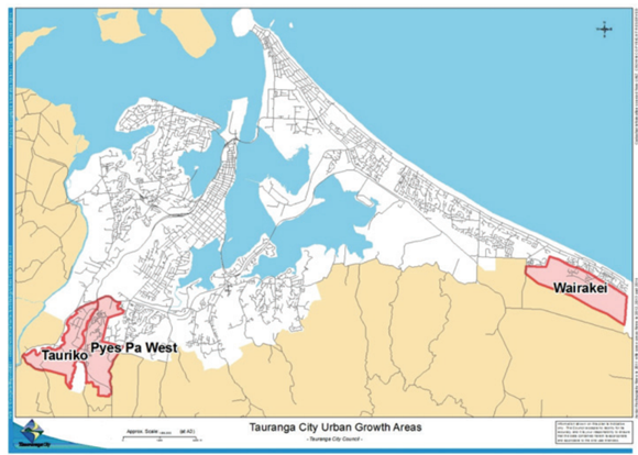
As indicated in the following map, the major growth areas currently under development and still requiring major infrastructure investment include:
- Tauriko Business Estate
- Wairakei
- Pyes Pa West.
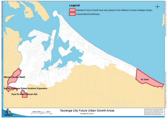
And the next map shows where, over the next 30 years, SmartGrowth indicates a number of new growth areas within Tauranga:
- Tauriko Business Estate southern expansion
- Keenan Road
- Te Tumu
- Wairoa
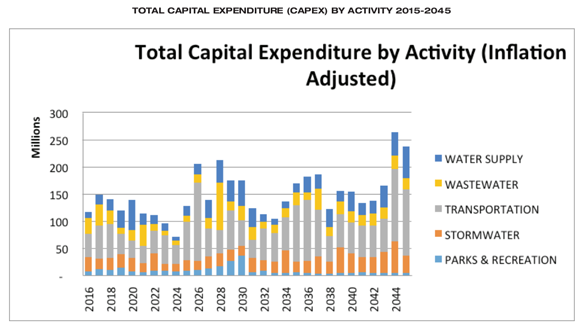
Based on these population assumptions the document then goes on to plan the investment in:
- Water supply
- Wastewater
- Stormwater
- Transportation
- Parks and Recreation
The numbers are staggering:
 Let me give you just a couple of project examples from each category.
- Water Supply:
- $65M for the 2017-21 Waiari Project incl intake, treatment plant, reservoir, trunk mains
- $24M for the 2042-45 Waiari Trunk Mains
- Wastewater
- $36M for the 2015-2017 Southern Pipeline completion
- $46M for the 2028 Te Maunga ocean outfall and diffuser
- Stormwater
- $7.2M for the 2022 Wairakei Stream to Kaituna Overflow
- $12M for the 2044 New reticulation future urban growth area
- Transportation
- See below for more detail
- Parks and Recreation
- $14M for the 2016-2024 Parau Farms Active Reserve
- $4.5M for the 2019 Te Tumu Reserve land purchase
- $4M for the 2044 Wairakei Community Centre
Transportation
I found the transportation section the most interesting.
Here are some stats on 2015 traffic levels:
- Cameron Road – 26,000 vehicles per day including 800 heavy commercial vehicles
- Girven Road – 20,500 vehicles per day including 800 heavy commercial vehicles
- Waihi Road – 18,500 vehicles per day including 550 heavy commercial vehicles
- Totara Street – 17,900 vehicles per day including 1,800 heavy commercial vehicles
- Maunganui Road – 15,500 vehicles per day including 775 heavy commercial vehicles
More stats on the transportation assets I found interesting:
- Around 515 million vehicle kilometres are traveled on the Tauranga transport network annually – this excludes additional trips on State Highways
- 536km of roads. Tauranga’s road network grows by 8-10km per year
- 12,106 streetlights
- 12 bridges
- 705km of footpaths
- 35 sets of traffic signals
- 10,080 stormwater sumps
- 115.4ha of mown grass
- 143 bus shelters
- 160 pay and display machines
- 222 speed humps
- 74 pedestrian refuges
- 90 roundabouts
Infrastructure Project Examples
And finally, I picked out a few items from the list of planned projects:
- $5M for the 2021-22 Elizabeth St Carpark extension
- This was fast tracked to 2016 because the mould issue in the Council building created the Civic Heart project, which may include a parking building within it, so planning for construction of a new stand-alone parking building was also interrupted
- $24M for the 2016-18 New CBD parking building
- Deferred because of Elizabeth St Carpark project being fast-tracked
- $8M for the 2019-2028 LED street lighting upgrade
- $60M for the 2026 15th Ave/Turret Road four laning
- I wonder how Welcome Bay residents feel about putting up with the congestion on Turret Road for another 10 years? And if it was build would that solve the problem or just move the bottle-neck to Cameron Rd?
- What other alternatives are there we not thinking about? Eg a supermarket in Welcome Bay might cut back some of that traffic? Free buses every 15mins?
Your Thoughts?
What do you think of my notes? Anything that catches your eye? Have your say in the comment section below.
You have done a good job and should be commended for all the background reading you have done in relation to council matters.
Geoffrey
Thanks Geoffrey!