Here is my summary of SmartGrowth 2013 (184 pages. 20Mb .pdf).
What is SmartGrowth?
- SmartGrowth is the “spatial plan for the western Bay of Plenty sub-region”, what this means is that it looks 50 years into the future and identifies the impact that our growing population will have on our city.
- Particularly, the stress on infrastructure that will result from an increase in urban density, and what farm land we will need for new suburbs, industrial areas and commerce, and what investment will be required to supply those new suburbs with essential services (water, waste water, storm water and more).
Six “Interest Areas”
The SmartGrowth strategy is based around 6 “interest areas” which cover the range of social, cultural, environmental and economic well-being’s.
The interest areas are:
- Strengthen Visionary Leadership and Collaboration
- Strengthen relationships with the community
- Strengthen and maintain relationships between implementation partners
- Strengthen our relationship with central government
- Strengthen our relationships with the upper North Island
- Strengthen our relationships with the wider Bay of Plenty
- Align the implementation toolkit
- Provide guidance
- Investigate collaborative funding options
- Greater accountability, reporting and review
- Sustain and Improve the Environment
- Promote sustainable use of resources
- Protect, restore and maintain the amenity of our unique environment
- Environmental Monitoring
- Build the Community
- Build and value partnership with the community
- Plan for infrastructure to support communities
- Consider the implications and opportunities of an ageing population
- Provide tertiary education opportunities
- Promote arts and cultural initiatives
- Provide transport to connect communities
- Grow a Sustainable Economy
- Create an enabling business environment
- Strengthen connections
- Encourage a thriving city centre
- Consider the implications and opportunities of changing demographics on the economy
- Improve housing affordability
- Recognise tangata whenua cultural identity and change
- Recognise tangata whenua interests and values
- Provide for the use of tangata whenua lands and waters
- Plan for changing Maori demographics
- Integrated Planning and the Settlement Pattern
- Demographic analysis/modelling
- Residential land
- Business land
- Managing the risk of natural hazards on the settlement pattern
- Strategic transport
- Cost effective infrastructure
47 pages of this 184 page report breaks down each of these items and they are discussed in terms of the desired outcome, the issues involved and the principles behind it.
Then, a list of actions is listed, a lead agency is assigned to deliver each action, and a timeframe is proposed, as well is an estimate of staff involvement and cost, and a success measure stated.
Let’s take a closer look at one example.
Under the “Build the community” section, 9F identifies a priority action:
- Promote and provide for walking and cycling
- Continue with planned implementation of walking and cycling routes by seeking opportunities to provide routes for walking, cycling and mobility scooters integrated with the provision of roads and other infrastructure.
- Investigate new cycling commuter routes and prioritise their development.
- Investigate and support opportunities to connect existing walking and cycling routes for recreational use throughout the sub-region.
And the lead agencies are jointly:
- Tauranga City Council
- Western BOP District Council
- NZ Transport Agency.
The resources set for this action are:
- Time: “ongoing”
- Staff Resource: Green which means “Able to be resourced using partner staff resources or within existing work programmes”
- Funding Resource: Navy blue which means “Potential for partner funding/resources outside SmartGrowth partnership“ with three asterix’s which means “Investigation may result in consequential cost to implement recommendations”
And the measures of success are set to:
- Identification of specific actions and agreed programmes as part of the Regional Walking and Cycling Strategy 2009 and the Tauranga Transport Strategy 2012-2022.
- Key cycling commuter routes are identified and prioritised in a timely manner
- The new routes form part of structure plans for new development areas
Part C: Settlement Pattern
Part C of the SmartGrowth document is the Settlement Pattern and takes almost 100 pages of this 184 page document.
There were 3 things that stood out to me in this section:
- How much of a priority the corridors are
- Where future industrial land will be
- And the benefits of residential intensification but why it hasn’t happened
The 5 Corridors
The document starts with background into why the SmartGrowth corridors are important:
- The Northern corridor to connect us to Auckland
- The Eastern corridor to connect us to Rotorua and Whakatane
- The Southern corridor to connect us to Rotorua and Taupo
- The Western corridor to connect us to Hamilton
- The Central corridor to connect the CBD with the suburbs
The Future
Next, information is provided on:
- Population projections (275,000 people by 2051)
- Capacity of present and future suburban areas
- The impact of urban growth on productive rural land
- Risk of natural hazards (tsunami and liquefaction)
Next, the strategy of residential infill and intensification is discussed.
Residential Infill and Intensification
This was particularly interesting because this tool could delay suburban sprawl and delay our city increasing our debt levels to fund that infrastructure investment.
But it turns out that developers and residents have been slower than first projected at taking up this option.
Several reasons were given, two examples are:
- “medium and high density living are still relatively unfamiliar to most New Zealanders”
- “the absence of drivers such as severe traffic congestion, long commuting times and distances”
Business Land and Infrastructure
Next, business land is discussed and infrastructure projects including roading and wastewater pipelines, and how they might be funded.
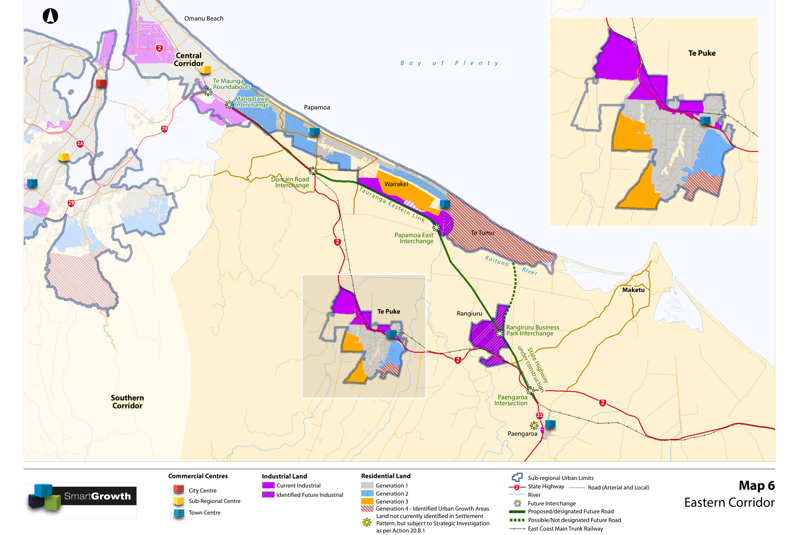
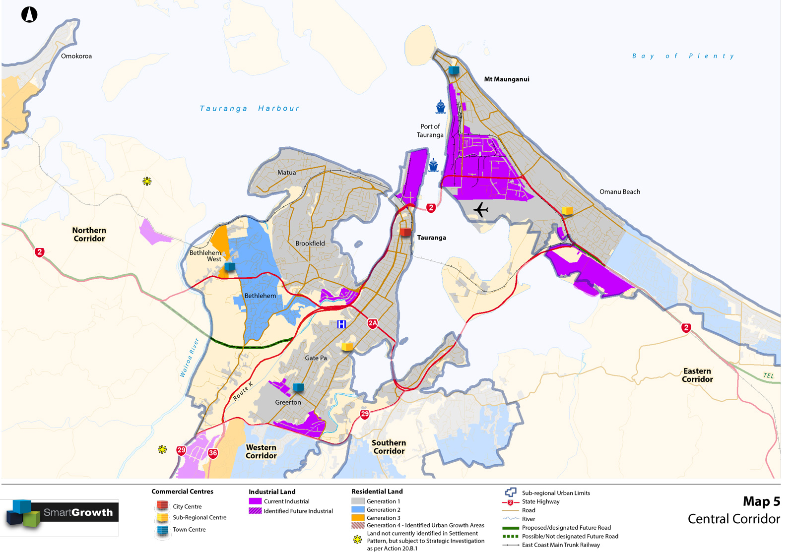
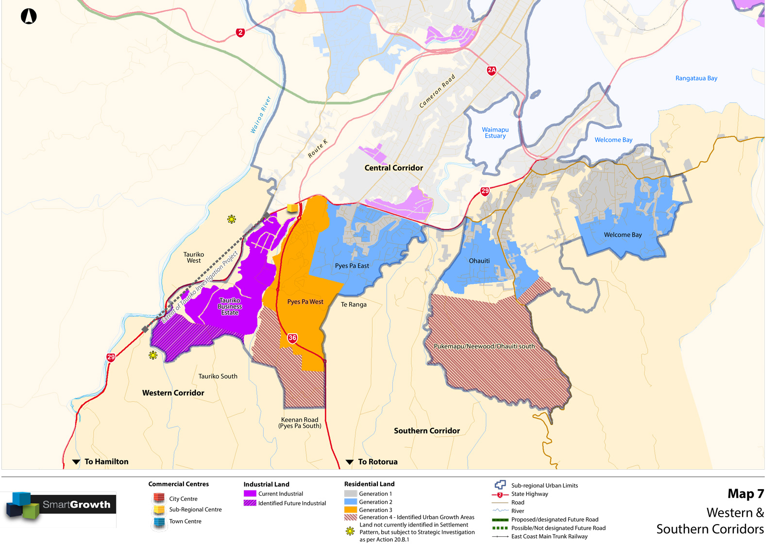
Maps
The maps were particularly interesting.
For this first one, note the huge Rangiuru Business Park Interchange, and the huge Te Tumu residential area in East Papamoa.
In this next one, look at the 2 stars on the left side of the map which indicate potential future residential development:
In the next map look at the extension of industrial land below the current Tauriko Business Estate, the residential extension to Pyes Pa West and the large residential extension South of Ohauti:
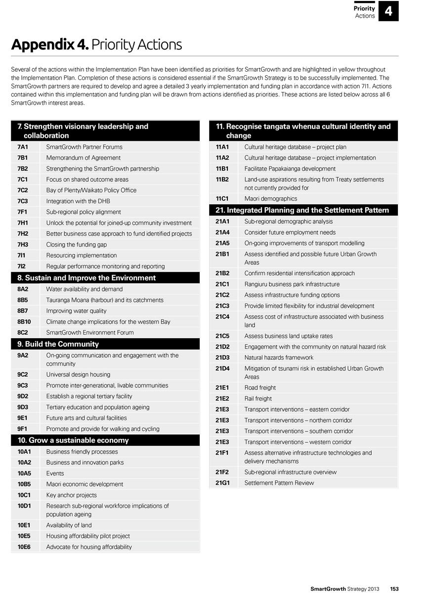
Action List
Finally, the actions are listed.
Here’s a list of the priority actions for the document:
Collaboration
The number one thing that stood out to me above all, when reading this 184 page report, was the level of collaboration and inclusion.
At the end of the document is a list of acknowledgements of all the organisations, and individuals that contributed to this strategy.
It is a list of 192 names of members of implementation committees, partner forums, Tangata Whenua, advisory groups, and working groups which include people from all 3 councils, central government organisations like NZTA, businesses, education groups, industry and the community.
Some names appear several times for different roles which would improve collaboration between groups.
Here is the list:
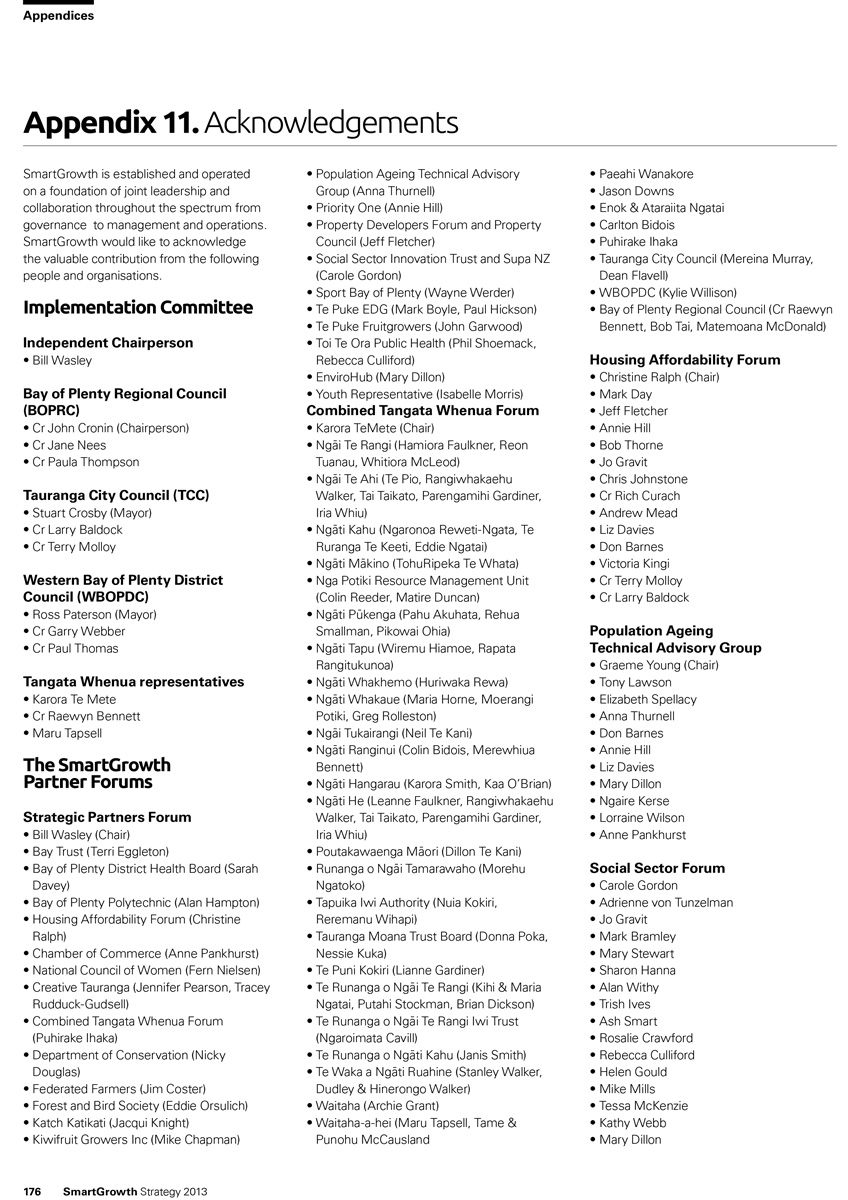
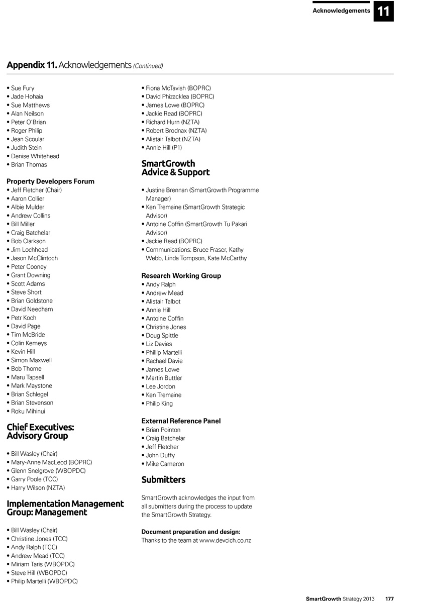
I admire the organistation skills that has gone into arranging meetings for those groups, extracting their contribution, and weaving their ideas into the final strategy.
Your Thoughts?
Have you read through, or been a part of, the SmartGrowth strategy? What do you think?
Have your say in the comments section below.